
|
Cummings
Creek Sub Basin
|
Cummings Creek is within the Cummings Creek Sub Basin, comprising a total of 8,065 acres, with 5,132 of those acres residing in the property boundary of the Pacific Lumber Company. The area is dominated by second growth Redwood, Douglas Fir, Grand Fir, with 2-3% hardwoods (tanoak, pepperwood, and big leaf maple).
The following two paragraphs describe Cummings Creek, and are taken from the Cummings 09 Timber Harvest Plan, 1-07-049 page 95.
"The upper portion of Cummings Creek is confined to a narrow canyon with moderate to high levels of overstory shade canopy and numerous pools. The lower three or four miles of Cumming Creek flow across a zone of deposition where the gradient of the stream decreases. Based on field observations in this lower portion of the drainage, active bank cutting from high winter flows is evident, as are suspended terraces and old stream channels. Inspections of the lower portion of Cummings Creek did not reveal any significant sediment related impacts, such as embedded gravels or filled pools.
The most apparent problems along lower Cummings Creek are a lack of overstory shade canopy and large organic debris in the stream channel. The lack of overstory canopy along lower Cummings Creek appears to be a combination of the removal of old growth timber from the alluvial flats along the creek and the conversion of forestland to pastureland for cattle grazing. The lack of large organic debris (LOD) in this stream channel appears to be associated with the size of Cummings Creek in the lower reach. High winter flows wash most LOD downstream. However the lack of large, old growth trees along Cummings Creek for recruitment most likely contributes to this condition; small trees with small root masses are easily washed downstream in high flow events."
There has been extensive interest in the Cummings Creek area for many key reasons: The creek runs through a residential area, and one of the bridges connecting one family of residents to their property was damaged in a storm. The Eel River Watershed Improvement Group was involved with Pacific Lumber Company in extensive restoration work of the bridge and a trail. Residents are actively involved with state agencies, such as the Department of Forestry and the Department of Fish & Game. The Jorgenson family, which lives near the stream, has been involved with water and macroinvertebrate studies for many years. Cummings Creek, which used to be a salmon-bearing stream, has experienced severe declines in salmon population over the past decade. Residents have seen the tremendous decline in salmon population over the past decade. A significant run occurred in 2001 but very few Chinook have been sighted over the past six years. Extensive and intensive timber harvesting have occurred on Cummings Creek over the past decade and continue to this day. Lower Cummings Creek dries up each year at the bridge on Highway 36, due to the stream going underground, a result of watershed impairment over time.
Part of lower Cummings Creek has become an illegal dumpsite Middle Cummings
is the location of our Turbidity Threshold Station (TTS) installed in
January, 2007 with the help of Salmon Forever. The station is maintained
by Jesse Noell of Salmon Forever. The Van Duzen Watershed Project (VDWP)
has established two turbidity monitoring sites on Cummings Creek, one
at the Jorgenson's, and one at Lower Cummings Creek near the junction
of Highway 36.
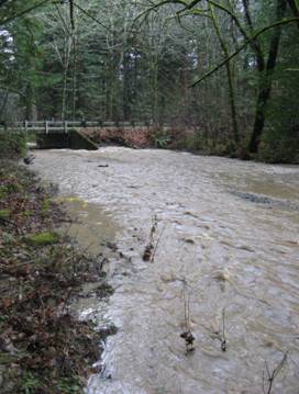
In the Summer, Lower Cummings Creek goes underground at the junction
of Highway 36, as shown in the photo below, left. Low water can be contrasted
with the major storm event of January 3, 2008, shown in the photo below,
right.
|
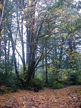
Lower
cummings Creek, November 2007
|
Lower
cummings Creek, January 2008
|
|
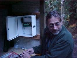
Jesse
Noell installing data logger
|
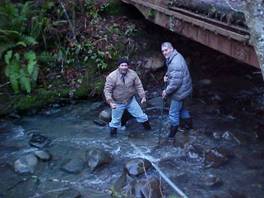
Sal
and Paul installing line into creek
|
Photo
of Cummings Creek after storm event on January 3, 2008,
looking upstream from the bridge at the Jorgensons.
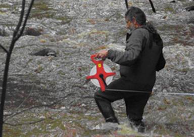
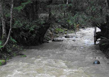
Jesse
Noell, who manages the TTS station,
taking discharge measurements across the stream.
The Cummings Creek stations are a major site for our turbidity and suspended sediment investigation into the Van Duzen River Basin. For more statistical information, please note the graphs from the 2007 Hydrologic Year and the Monitoring Report for 2007, which can be viewed on our website, www.fovd.org.